
MARINE ELECTRICAL RESISTIVITY TOMOGRAPHY
Marine Electrical resistivity Tomography is one of the unique expertise of MAPPEM Geophysics. It consists in imaging the electrical resistivity of the sub-bottom. This unique physical property of the materials corresponds to their ability to let an electric current flowing through it. The electrical resistivity is a distinguishing parameter of the geology, and it can vary by several orders of magnitude depending on the material. In fact, imaging the resistivity of the subseabed allows inferring its compaction, density, type and its geometry.
Applications
Our systems are made to perform resistivity imaging in all coastal areas, regardless of water depths and substratum.
Among the fields of application, we can provide our services within the framework of:
- Building of maritime infrastructures
- Cable routes for Marine Renewable Energies
- Sand detection and other geophysical services for dredging activities
- All engineering activities requiring a thorough knowledge of the marine subsoil geology
The MAPPEM system
Electrical resistivity tomography system
Electrical resistivity tomography was first widely used for land exploration.
The MAPPEM Geophysics team has reinvented this technique by developing a unique and powerful system for the study of the marine environment: the MAPPEM.
This system has been designed to be easily deployed offshore from a ship. Our innovations in the electronic equipment and data processing chain are able to handle the strong contrasts in resistivity between seawater and seabed, a technical challenge that had previously limited the development of electromagnetic imaging in the marine domain.
We carry out resistivity imaging campaigns using our MAPPEM system, developed for the coastal marine domain. This system is adapted to the study of geology at a depth of several dozens of meters.
BURIED OBJECT DETECTION
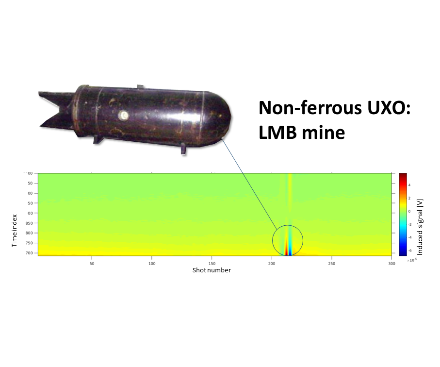
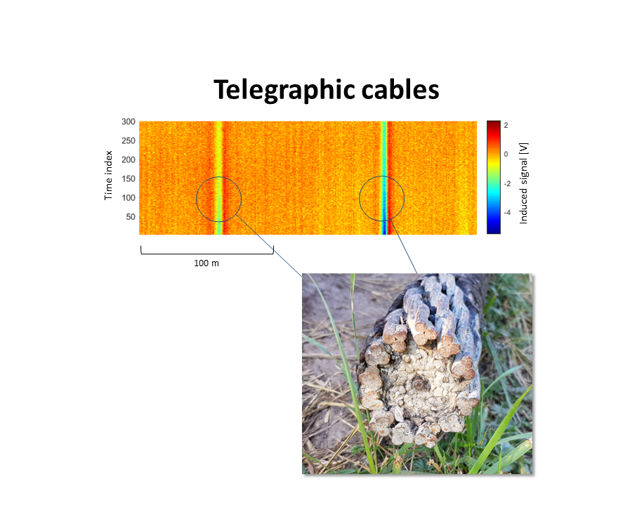
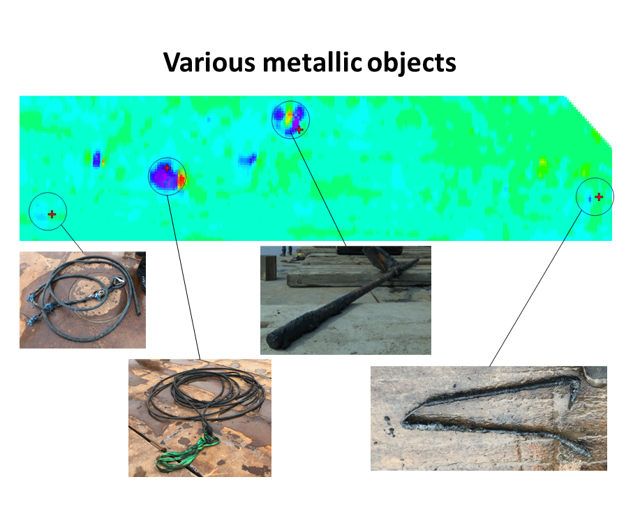
The unique MAPPEM technologies allows enlightening electromagnetic signatures corresponding to objects’ capacity to conduct electric current. In a homogeneous geological environment, objects have a very clear and easily distinguishable electromagnetic signature, often easier to detect than their acoustic signature. This electromagnetic visibility makes it possible to identify objects buried at a few meters below the seabed and turns MAPPEM techniques into a privileged means of detection and tracking of buried objects.
Using our proprietary “BODIES” data processing, the MAPPEM system can detect any metallic object, regardless of the type of metal (aluminum, titanium or copper alloys).
We can thus efficiently detect pipelines, cables and UXOs that are often difficult to locate, especially if their magnetization or ferromagnetic content is low or if the environment is masking them.
Applications
The MAPPEM electromagnetic systems allow the detection of objects in all coastal areas, regardless of the water depth.
Among the application areas, we can cite the following ones :
- Securing sites for offshore works (dredging, infrastructure construction, MRE) by detecting UXO or obstructions
- The buried cable tracking for MRE or telecommunications
- Pipeline tracking for Oil & Gas
- Underwater archaeology
- All maritime activities requiring the detection of anthropic objects.
MEASUREMENT OF ELECTROMAGNETIC FIELDS
MEASUREMENT OF ELECTRO-MAGNETIC FIELDS
The development of new infrastructures such as for the Marine Renewable Energies or other coastal facilities leads to an increasing need to assess the impact of these marine structures on the environment.
An important but hardly studied topic is the electromagnetic signature of energy cables and infrastructures and their possible impact on the environment and ecosystems.
An electromagnetic environment survey should include a zero-state assessment of electromagnetic fields before installation of the infrastructure. Further investigations are then programmed to assess the evolution of electromagnetic fields.
Our precision systems are also used for cathodic protection monitoring, defense purposes and marine magnetotelluric geophysical studies.
Applications
Our electromagnetic systems allow the measurement of electromagnetic fields in all coastal areas, regardless of the water depth.
Within the application areas, we particularly operate for :
- The study of the impact of power export cables on the environment
- The study of the impact of MRE structures on the environment
- Any other civil or defense activities requiring electromagnetic monitoring, including cathodic protection monitoring
- Marine magnetotelluric studies.
Our systems
We have developed two innovative instruments to measure marine electromagnetic fields: the PASSEM system and the STATEM system.
- The PASSEM is a towed instrument capable of measuring marine electromagnetic fields (electric dipoles and 3-axis magnetometer) with a high accuracy and resolution. The PASSEM system can record EM signals over a large area in a short time.
- The STATEM system has been developed to perform seafloor measurements. It is deployed for several days (up to one month) and then recovered for data analysis.
R&D IN Marine ELECTROMAGNETISM
R&D IN marine ELECTRO-MAGNETISM
The geophysicists and engineers of MAPPEM Geophysics combine a vast experience in the conception and development of unique marine instruments, from deep ocean stations to shallow water towed or seafloor systems.
In parallel, intensive research is also carried out on the development of numerical codes to solve the mathematical equations expressing the electromagnetism associated with the MAPPEM systems, in order to improve data processing (direct calculation and inversion) and to optimize the geometry of the MAPPEM set-ups.
As experts in electromagnetic measurements, the MAPPEM Geophysics team develops state-of-the-art instruments for a wide range of purposes, from instrumentation for geophysical applications to passive or active electromagnetic devices and systems.
Applications
The MAPPEM expertise in theoretical calculations and instrumentation development is dedicated to innovation in marine electromagnetics with various applications.
For example, we develop with our client and partners new products in the fields of:
- Environmental studies (electromagnetic signatures of anthropic infrastructures and cathodic protection studies)
- Defense applications (harbor protection, signatures management, object detection and characterization, etc.)
- Geophysical imaging and quantitative geophysics.
- Other non disclosed subjects.
Some R&D projects examples
Some of our past or ongoing R&D projects:
- CITEPH: localization of buried objects with ENTREPOSE, SAIPEM and TECHNIP
- CMI (Concours Mondial Innovation): deep-sea exploration (French government grant). Phase 1 and 2 with various partners (Créocean, ECA, RTSYS, Naval Group)
- DGA projects regarding electromagnetic signatures
- GRAVIMOB: Development of a mobile marine gravimeter (with UBO, University of Brest)
- SPECIES: Electromagnetic impact of MRE projects on the environment (France Energie Marine and other partners).
- GEOSISMEM: Going toward quantitative geophysics using resistivity imaging
- Other Defense projects.
